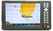
Ship GPS chart / Fish finder
Model:LER-7
Application of advanced fishing technology to eliminate all noise and interference, high-resolution analysis to the sea floor. There are many different display modes, including charts, fishing surveys, navigation data, compass, AIS, satellite wind direction and wind speed, etc. It accepts external GPS, AIS, wind direction and wind speed, water depth, temperature and pressure input, and can be displayed on the AIS radar screen, chart screen and data window in the same machine. It is also free to output different data with different baud rates to other marine instruments, such as autopilot radar.
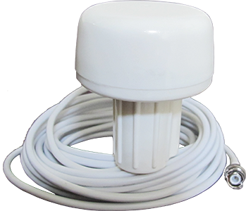
Built-in high-performance GPS antenna, or external GPS antenna.
Features
◎ Dual chart system
◎ AIS data of external access can be displayed
◎ Built-in GPS antenna
◎ Large-capacity memory
|
Product acessories
◎ Display
◎ Instruction manual * 1 volume
◎ Installation material
◎ Standard spare parts
|
Specification
Overall size: 243mm × 155mm × 82mm
Weight: 0.6kg
Display: 7.0-inch LCD
Pixel: 800 * 600 pixels
Waterproof rating: IPX5
Ambient temperature: -15 ° C to + 50 ° C
Power supply: 10.5 to 35VDC
More
 |
 |
 |
| TL188 |
GPS Antenna |
LER-1002 |